![]()
Acrobat 9 and Reader and geospatial
By Jeff Moran – July 25, 2008
In this tutorial, learn how to use the geospatial feature set in Adobe PDF and in Acrobat and Reader 9.
Location, Location, Location
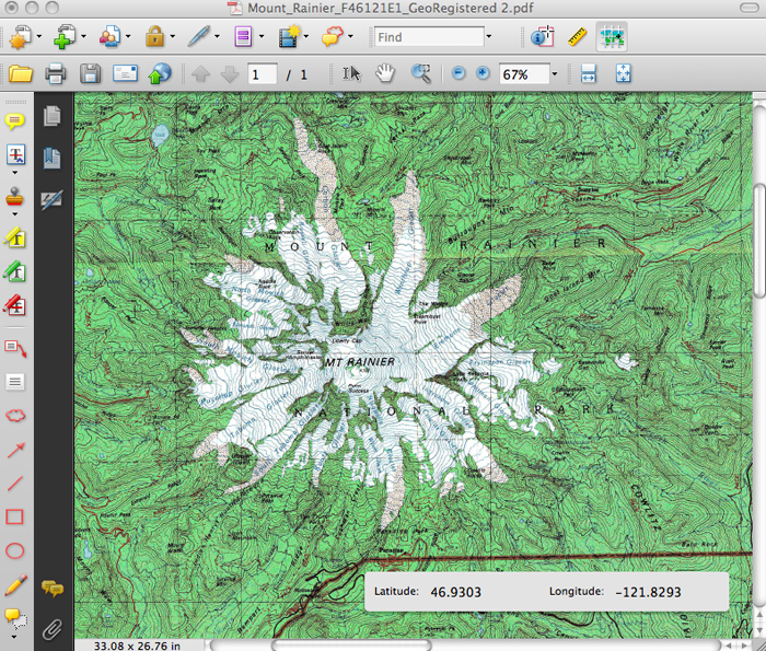
With version 9 of Acrobat or Reader, if a PDF file is geospatially aware, you can consume the coordinates using the Geospatial Location Tool via the Analysis toolbar (Tools > Analysis).
- Use the tool to view coordinates in Decimal and DMS format (degree minutes seconds), using signed or named settings. View the coordinates in a pop-up widget in the lower right hand corner of the screen (see screen shot below).
- Find a location in a map and mark it with a comment by right-clicking. The comment will capture the coordinate location in the text of the comment and the PDF information.
- Measure places on a map using real-world units, such as miles, kilometers, feet, etc. Zoom your view mode in and the scale is adjusted so that you can continue to measure accurately. No need to manually readjust your scale.
The Geospatial Location Tool and Measure Tool are available in Acrobat Standard (Windows), Acrobat Pro (Macintosh and Windows) and Acrobat Pro Extended (Windows). Reader contains the Geospatial Location Tool and PDF authors can Reader-Enable a PDF file to turn on the Measuring and Commenting tools.
PDF Map Authoring
In Acrobat Pro Extended you can actually author PDF Map files. You can do this in a few ways.
- Open a Tiff or Jpeg 2000 file that contains geospatial information in Acrobat Pro Extended. The resulting PDF file that is saved will retain this information.
- From a Map image file (scanned or already in PDF/image format), if you know the map projection and some coordinate information, you can use Acrobat’s Geospatial Registration tool to add coordinate information to the PDF.
- Add Shape (SHP) files to a PDF file using the Import Layer functionality. This allows the PDF document author a way to create viewable layers on a map that can be turned on and off in the Layers Panel.
Third-Party applications will soon begin to produce PDF Map files. ESRI’s AcrGiS 9.3 already does this.
PDF Geospatial information
The new geospatial information in PDF will be proposed to the ISO Standards group. Leonard Rosenthol owns this work for Adobe Systems. ISO 32000-1 is PDF 1.7 and has already been ratified by the ISO. The geospatial information will be submitted as Adobe Extension Level 3 for PDF 1.7 (or 1.7-ADBE-3 for short). So if you create a PDF with Acrobat Pro Extended 9 and it contains geospatial information, it will show up in the Document Info dialog with that designation.
What does this all mean for you?
So we put coordinate information into PDF and allowed you a way to view and consume this information. Why is this important? By allowing PDF to now work with geospatial information, Adobe has provided a document platform for GIS customers to use. No special tools and no special extensions to PDF are needed. Suddenly all the Acrobat document features are now available to customers working with geospatial documents.
Many industries interact with geospatial information: Architectural, Engineering, CAD users, Mining, real-estate, government and military industries. These are large industries with many potential customers. Now their traditional document work flows that could only include flat image maps now can include fully functioning PDF Maps.
Traditionally the pain points have been:
- Geospatial digital files were too large to pass around and combine into one document.
- Special application viewers were needed; often times only PCs could be used.
- Info-rich files outputted by a GIS application are eventually flattened and less interactive as they are used.
Now PDF files and PDF Portfolios can contain geospatial information, which makes document presentations more valuable. Anyone with Adobe Reader 9 can view the file.